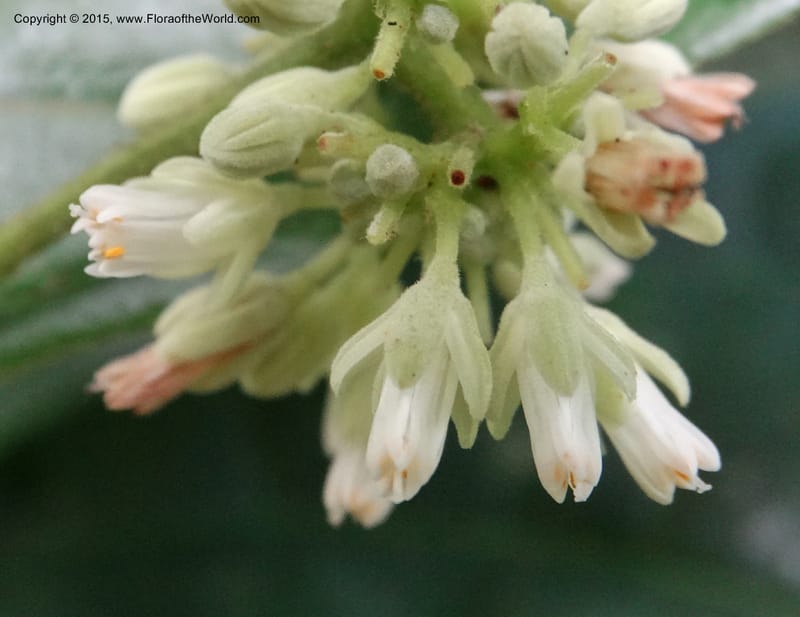
Tapura, Davidson, C 12381--Cameroon. Bakengili Trail, Mt. Cameroon. 24 Mar 2014. DSC03587 (136).JPG
Native to 87 botanical countries across Africa, Temperate Asia, Tropical Asia, Australasia, Pacific, Northern America, and Southern America (source: POWO). Flora of the World documents 7 occurrences across 4 countries.
Location
Cameroon, Southwest
4.085056, 9.050194
Location Remarks
S end of Mount Cameroon National Park. Bakingili Trail from Bakingili Village on Hwy N-3. Various places along trail N toward park boundary. Elev. 300 m.
Collectors
Christopher Davidson, David Kenfack, Paul Ndumbe, Elias NDive, Sharon R. Christoph
Notes
Primary lowland rainforest (Atlantic Tropical Forest). Liana.
Location
Madagascar, Vatovavy-Fitovinany
-21.331944, 47.673889
Location Remarks
About 7 km E of Ifandiana on National Route 45. Vegetation overhanging roadside along southern side of road. Degraded.
Collectors
Peter B. Phillipson, Zachary Scott Rogers, H. Razafindraibe, Christopher Davidson
Location
Madagascar, Atsimo-Atsinanana
-23.058889, 47.724722
Location Remarks
Atsimo Atsinanana, collecté le long de la route entre Farafangana et Vangaindrano.
Collectors
Peter B. Phillipson, Zachary Scott Rogers, H. Razafindraibe, Christopher Davidson
Location
Madagascar, Diana, Antsiranana
-13.413056, 48.335556
Location Remarks
Nosy Be, SE corner of island in Lokobe Forest. Along sandy beach. Specimens preserved in alcohol.
Collectors
Zachary Scott Rogers, Rolland Ranaivojaona, Christopher Davidson, Sharon R. Christoph, Fidi Ratovoson
Location
Malaysia, Sabah, Tawau (Lahad Datu)
4.960944, 117.802889
Location Remarks
Danum Valley Conservation Area. Danum Valley Research Center. Loop trail along river. 164 m elev.
Collectors
Postar Miun, Jeisin Jumian, Christopher Davidson, Sharon R. Christoph, Martin W. Callmander, Sven Buerki
Notes
Liana.
Location
Madagascar, Atsimo-Atsinanana
-23.058889, 47.724722
Location Remarks
Atsimo Atsinanana, collecté le long de la route entre Farafangana et Vangaindrano.
Collectors
Zachary Scott Rogers, H. Razafindraibe, Christopher Davidson, Sharon R. Christoph, Peter B. Phillipson
Location
Gabon, Moyen-Ogooue
0.81275, 10.500333
Location Remarks
Mabounie. Off route N1, ca. 41 km ESE of Lambarene, then left (c. N) at Lobi-Mbigou. Mine access road about half way to the river Ngounie (GPS is from the road terminus at the river). 92 m elev.
Collectors
Christopher Davidson, David Kenfack, Nestor Engone Obiang, Sharon R. Christoph
Notes
Upland moist forest somewhat impacted by selective clearing. Roadside bank. Scandent shrub 1 m.
Kingdom
Plantae
Phylum
Tracheophyta
Class
Magnoliopsida
Order
Malpighiales
Family
Dichapetalaceae
Genus
Dichapetalum
Authorship
Thouars