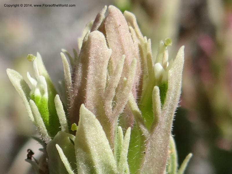
Castilleja, Davidson, C 12200--ID. Custer Co. 1.6 mi from Hwy 75 on Redfish Lake Rd. 13 Jul 2013. DSC06785 (71).JPG
Native to 109 botanical countries across Europe, Temperate Asia, Northern America, and Southern America; introduced into Hawaii; extinct in Delaware, Massachusetts (source: POWO). Flora of the World documents 9 occurrences across 2 countries.
Location
United States, Idaho, Custer
44.149139, -114.916833
Location Remarks
Redfish Lake
Collectors
Christopher Davidson, Sharon R. Christoph, Roy E. Gereau, Charlotte M. Taylor
Notes
Artemisia flat in lodgepole pine forest.
Location
Ecuador, Pichincha
0.021944, -78.746944
Location Remarks
Along road between Tandayapa and Mindo, vicinity of Bellavisata Tourist Lodge, 6.5 km N of Tandayapa on old road from Nono to Mindo. 2270 m elev.
Collectors
Carmen Ulloa Ulloa, Christopher Davidson, Sharon R. Christoph, J. Irazábal
Notes
Hierba, 10-15 cm, hojas con tintes marrones, punta de las hojas apicales rojo-anaranjado, flores verdes.
Location
United States, Idaho, Adams
45.189778, -116.304556
Location Remarks
Hwy 55 along the Little Salmon River. Ca. 19 km S of Pollock. Coarse basalt gravel on roadside turnout above the river. 976 m elev.
Collectors
Location
United States, Idaho, Adams
45.189778, -116.304556
Location Remarks
Hwy 55 along the Little Salmon River. Ca. 19 km S of Pollock. Coarse basalt gravel on roadside turnout above the river. 976 m elev.
Collectors
No collectors specified
Location
Ecuador, Carchi
0.802222, -77.929167
Location Remarks
Paramo del Angel, along road from El Chical to Tulcán, 68.1 km E of El Chical, 13.6 km W of Tufiño plaza. 3200 m elev.
Collectors
Tom B. Croat, Christopher Davidson, Sharon R. Christoph
Notes
Bracts green, tip of sterile bracts red-orange.
Location
United States, Idaho, Valley
44.158, -116.118361
Location Remarks
Highway 55 c. 10 km north of the bridge at Banks. Mixed conifer forest along the N. Fork Payette River.
Collectors
No collectors specified
Location
United States, Idaho, Idaho
45.244, -115.588639
Location Remarks
1.9 km N of Warren Summit on FSR 340, at Mayflower Creek Bridge. Elev. 1904 m.
Collectors
No collectors specified
Location
United States, Oregon, Harney
42.666944, -118.711194
Location Remarks
South Steens Mountain Loop, c. 6 km east of bridge at Donner and Blitzen River. 1806 m elev.
Collectors
Christopher Davidson, Charlotte M. Taylor, Roy E. Gereau, Sharon R. Christoph
Notes
Sagebrush steppe with stunted aspens.
Location
United States, Oregon, Wallowa
45.579306, -116.960556
Location Remarks
The Nature Conservancy's Zumwalt Prairie Preserve. 0.6 km NE past Summer Camp barn on Trail Creek Rd. Elev. 1371 m.
Collectors
Christopher Davidson, Sharon R. Christoph
Notes
Gently sloping meadow. Bracts white.
Kingdom
Plantae
Phylum
Tracheophyta
Class
Magnoliopsida
Order
Lamiales
Family
Orobanchaceae
Genus
Castilleja
Authorship
L.f.