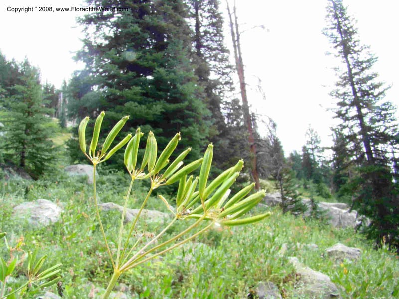
Osmorhiza occidentalis, CDavidson11261--IID. Valley Co. Trail to Box Lake. 8 Jul 08. 028b.jpg
Native to Alberta, British Columbia, California, Colorado, Idaho, Montana, Nevada, Oregon, Utah, Washington, Wyoming (source: POWO). Flora of the World documents 7 occurrences across 1 country.
Location
United States, Idaho, Valley
44.158, -116.118361
Location Remarks
Highway 55 c. 10 km north of the bridge at Banks. Mixed conifer forest along the N. Fork Payette River.
Collectors
No collectors specified
Location
United States, Idaho, Bear Lake
42.431667, -111.562722
Location Remarks
Sherman Peak Area. Follow North Canyon Rd. (Forest Road 401) ) from Hwy 36 near E entrance to Emmigration Canyon. At intersection of Bartlett Lake and North Canyon Rd. (1.9 mi. from Hwy 36), go W on N Canyon Rd. past Mill Hollow Rd. At 4.7 mi. from Hwy 36 turn N at Meadow Creek (FR 425). Stop along Meadow Creek, ca. 0.8 mi. N of North Canyon Rd.
Collectors
Christopher Davidson, Sharon R. Christoph
Notes
Patches of Douglas fir on N slope, and maple-riparian along the creek.
Location
United States, Oregon, Harney
42.666944, -118.711194
Location Remarks
South Steens Mountain Loop, c. 6 km east of bridge at Donner and Blitzen River. 1806 m elev.
Collectors
Christopher Davidson, Charlotte M. Taylor, Roy E. Gereau, Sharon R. Christoph
Notes
Rocky hillside east of the road; within sagebrush steppe. Stems to 1 m.
Location
United States, Idaho, Fremont
44.289333, -111.459389
Location Remarks
Intersection of Hwy 20 and Pinehaven Rd. ca. 16 km S of bridge in Island Park and 26 km N of Main St. in Ashton. Elev. 1868 m.
Collectors
Christopher Davidson, Sharon R. Christoph
Notes
Riparian zone, Salix thicket with grassy clearings.
Location
United States, Idaho, Boise
44.083139, -115.754194
Location Remarks
Ca. 4.2 km N of Banks-Lowman Rd (Hwy 17) on Scott Mtn Lookout Rd. (FSR 555BC). Elev. 1170 m.
Collectors
Notes
Ponderosa Pine/Douglas Fir forest on steep, rock W slope above (E of) Big Pine Cr., with Prunus, Ceanothus, Balsamorhiza.
Location
United States, Idaho, Boise
44.083139, -115.754194
Location Remarks
Ca. 4.2 km N of Banks-Lowman Rd (Hwy 17) on Scott Mtn Lookout Rd. (FSR 555BC). Elev. 1170 m.
Collectors
No collectors specified
Notes
Montane; seasonally moist roadside in Abies forest.
Location
United States, Idaho, Valley
44.158, -116.118361
Location Remarks
Highway 55 c. 10 km north of the bridge at Banks. Mixed conifer forest along the N. Fork Payette River.
Collectors
Christopher Davidson, Sharon R. Christoph, Roy E. Gereau, Charlotte M. Taylor
Kingdom
Plantae
Phylum
Tracheophyta
Class
Magnoliopsida
Order
Apiales
Family
Apiaceae
Genus
Osmorhiza
Specific Epithet
occidentalis
Authorship
(Nutt. ex Torr. & A.Gray) Torr.
What is EDGE?
Evolutionary distinctiveness
Lower
ED 2.0
Part of a well-represented branch of the plant tree of life, with many close relatives.
Threat status
Modelled estimate
EDGE score
0.2
Global rank
#194,404 of 335,497
Top 58%
Extinction probability
11%